Hotel St James
Florence - Via XXVII Aprile 18
Book now

The Padule di Fucecchio is an area of considerable historical and environmental importance, both for the distinctive features it contains and for the opportunity it presents as a model for understanding the territory.
Its formation resulted from the gradual raising of the Arno riverbed, caused by the deposit of alluvial material. This prevented the natural drainage of all the water from the Valdinievole basin, causing the area to become marshland. Various watercourses from the surrounding hills converge in this area: the Pescia di Pescia, the Pescia di Collodi, the Pescia Nuova, and the streams Borra, Nievole, Vincio and other smaller ones.
Geologically speaking, its formation can be traced back 60 million years ago, when, during the Pliocene period, the Valdinievole territory emerged from the sea. Over the millennia, it was gradually filled in by sediments brought by numerous watercourses. Reaching this natural basin and unable to find free drainage, these watercourses caused the valley to become marshland.
The earliest records of intervention work to promote the drainage of the Padule di Fucecchio date back to the medieval period. In 1279, an order was issued to demolish mills, fish weirs and any other obstacles blocking the free flow of water along the Usciana outlet. However, as governments changed, so did the administrations’ attitude towards this land. With Florence’s dominance over the area, the Padule became a proper lake due to the barriers erected at Ponte a Cappiano. This measure had significant consequences for the area’s territorial organisation, and the progressive expansion of the marsh prompted protests from affected landowners. The contradictory policies of the Medici continued over the following centuries, alternating interventions at Ponte a Cappiano with minor land reclamation works that, among other things, led to the formation of seven farms.
Following various events that saw the Valdinievole affected by numerous malaria epidemics with serious hardship for the population, towards the mid-18th century Grand Duke Pietro Leopoldo took the first steps for the hydraulic and sanitary improvement of the area, ordering the demolition of the fish weirs and thus renouncing the benefits of fishing, the profits from mills and the rights acquired by his predecessors over the land around the Padule. Through these resolutions, Pietro Leopoldo sought to encourage agriculture and commerce in the area.
The Grand Duke also wanted to involve landowners directly in the planning of hydraulic operations and established in 1781 a Deputazione consisting of representatives from the five Imposizioni dei Fiumi of the Valdinievole and other proprietors. The aim was to organise land reclamation works financed by the landowners. However, after two years the Deputazione was dissolved because there were few financial contributions.
In 1786 a new Deputazione was created, defined as a “water consortium”, that is “an institution that allowed those interested to provide autonomously, though under the supervision of public authority, for the care of works assigned to them”. In 1803, under the Grand Duke’s government, the “Compulsory Consortium of the owners of land in the Padule di Fucecchio” was established, with the task of maintaining watercourses to enable both navigation and the exploitation and cultivation of land for agricultural purposes.
The policy pursued by the House of Lorraine was to some extent continued after Italian unification, when, as part of state-funded public works programmes, the Padule di Fucecchio was included among land reclamation projects and in 1928 the perimeter of the Padule Land Reclamation District was approved.
The Consortium became increasingly important until its recognition in 1931 as a “Land Reclamation Consortium”.
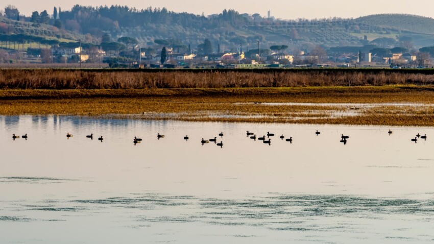
Despite being greatly reduced compared to the ancient lake-marsh that once occupied much of the southern Valdinievole, the Padule remains an area of significant natural interest, and at 1,800 hectares straddling the provinces of Florence and Pistoia, it is Italy’s largest inland marsh.
The central area, known as the Cratere, is affected by changes in weather conditions and is therefore almost dry in summer and full of water in winter. In this basin, which reaches a maximum depth of around 3 metres, water from rivers and streams collects. This water comes from a large catchment area and gathers in two large channels known as the Capannone and Terzo channels, which then flow into the Nuovo Canale di Bonifica, which at Ponte a Cappiano becomes the Usciana.
The Padule presents itself as a wetland rich in both animal and plant life: mammals, fish, molluscs, arthropods, bacteria, protozoa, algae, fungi and various microorganisms. It is home to plant species of boreal, alpine and high-montane types, and even Eurosiberian species, which arrived from the north during the glaciations of the Quaternary period that invaded parts of southern Europe and found conditions favourable for adaptation and survival here. The microclimate created over time in the Padule has made it possible for varieties not typically native to our area to survive, and has brought together floral elements of warm or oceanic climates with botanical species of northern and glacial origin. The marsh, which is considered one of the most important inland wetland areas in the peninsula, preserves many examples of wetland vegetation: sedge beds with their characteristic “sarello” tufts, reed beds, pondweed beds, damp meadows, wet woodland and royal fern.
In the past, the Padule was a paradise for hunters and fishermen, both for migratory game attracted by the water, and for resident game such as woodcock, snipe, quail, doves, thrush, pheasants, ducks, mallards and so on, or for the abundance of pike, eels, tench, carp, shad, small fry and roach; today pollution has reduced the presence of some animal species and in some cases caused their disappearance.
The spring passage of rare species such as the crane and the black stork remains a marvellous sight, as does the constant presence of animals such as the polecat and the porcupine. Increasingly frequent are encounters with the nutria, a large South American rodent similar to the beaver, which is colonising our wetlands ever more. Moreover, recently, with the establishment of a nature reserve, the presence of numerous species of herons has multiplied, and they increasingly choose this wetland area as a base for their nesting.
Still significant are the remains of human activity and the importance that the wetland has had in the past for the local economy: the channels, the port system, and the buildings of industrial archaeology.
In the municipal territory there are three large structures, real examples of industrial archaeology, which in relatively recent times served for the processing of tobacco grown widely throughout the area.
Also noteworthy are the buildings at Capannone, an ancient port that served the water-based transport network, which was once widely used in these areas. Here, alongside a small church now disused, you can see the old customs house intended for the storage of products arriving at or departing from the commercial dock.
In the first land registry (1789) Capannone, then still owned by Marchese Feroni, is described as a multi-functional architectural complex capable of meeting the needs of grain storage (storehouse with grain pits) and wine, construction and maintenance of small boats, and accommodation for staff assigned to supervision.
In the building, the ancient functions are still visible today, and a restoration that took account of the history of the channel, the building, the church and the grain pits could provide a rare testament to an economy based on the Padule and could lead to the recovery of a building of considerable importance for understanding the territory and scientific documentation of the past.
Worthy of special mention finally are the typical “casotti” (huts) that characterise the landscape of the area. Such structures, when life still animated these shores, were necessary for activities connected to the exploitation of marsh resources (fish, game, reeds and various plants), which were then very important for the local economy.
All these historical remains can be easily reached via various routes that are passable for much of the year except during periods of heavy rainfall, as in such cases the paths may be partially covered with water.
The Padule is also a place of sad memories. Passing along the Capannone channel, you will notice the numerous inscriptions bearing the names of people killed during the massacre carried out by the Germans on 23 August 1944. Plaques commemorating this barbaric event can also be found at the tobacco drying facility in the “Pratogrande” locality.
The current state of crisis in which the Padule finds itself is the result of unplanned territorial development, which was particularly evident in past years. In order to overcome this situation and actively recover what remains, local and other administrations have, for some years, recognised the need to implement a territorial urban planning scheme that, based on thorough knowledge of the territory, works to prevent future mistakes and correct past ones, in order to create a natural environment satisfactory to all.
From 1982 onwards, the Tuscany Region became involved in the formation of a system of protected areas, parks and nature reserves in Tuscany, and the councils involved, together with the Province, sought to cooperate to facilitate the implementation of the protected areas system, so that the Padule di Fucecchio would assume the value of a primary naturalistic hub, an element that would reorganise the entire Valdinievole and become, through river strips, a connecting element with the hillside environmental systems.
It was only in 1995 that the Tuscany Region issued regulations for the establishment and management of nature reserves under Provincial jurisdiction, and as a result the Nature Reserve called “Padule di Fucecchio” was established by Provincial Council Resolution in 1996, and with Provincial Council Resolution in 1997 the Regulations of this Nature Reserve were adopted. These pursue the protection and enhancement of the natural environment in all its components, the reconstruction or maintenance of an environment favourable to the stopover and residence of wildlife, the improvement of the quality of agricultural production, the promotion of new economic activities linked to tourism compatible with this particular environment, the implementation of programmes of study and scientific research aimed at understanding and improving the natural balance of ecosystems and natural landscapes, and the improvement of the relationship between mankind and nature.
The Municipal Administration has long been working to promote the enhancement of the entire marsh area, focusing its efforts on the reopening of navigable channels, pedestrian and cycling paths and the recovery of old buildings such as the Medicean Customs House at Capannone and the tobacco drying facilities, unique examples of industrial archaeology. The aim would therefore be to maintain these lands as “wetlands”, with necessary water remediation, to be linked to the architectural recovery of existing buildings.
Precisely to enhance this particular environment, a complex ecosystem whose physical, chemical and biological characteristics combine to form one of the most extraordinary life systems in our country, in October 1996 the Pescia/Padule route was promoted with the opening of a trekking path along the embankment of the Pescia di Pescia, then finishing along the Padule’s land reclamation channels. The paths form an intricate network across the surface of the marshy crater, with careful attention to the needs of those who wish to walk, cycle or ride horses through this protected area. We should mention that it is possible to visit the Padule by the characteristic small boats that some local residents still keep in the various ditches or channels – perhaps the most emotional and authentic way to experience this natural environment.
In the nearby municipality of Larciano, in the Castelmartini area, the “Research, Documentation and Promotion Centre for Padule di Fucecchio” was established at the end of 1990, composed of representatives of public bodies and associations, and is dedicated to the protection of this environment. Its aim is to promote the conservation and enhancement of the historical, environmental and naturalistic qualities of the Padule di Fucecchio and the nearby Sibolla lake, as wetlands of national and international importance. The Centre attaches particular importance to education and outreach activities aimed at all age groups, although greater focus is placed on school-age children. It promotes the study of the territory’s physical characteristics, visual documentation of the landscape’s seasonal variations, listening to the sounds of the marsh, direct observation of animal and plant species, and various traditional activities.
The Reclamation Consortium of the Fucecchio Marshland has very ancient origins: it was established in 1796. The organisation continues to exist today and remains highly active in the wetland area. Its jurisdiction extends across 57,000 hectares, covering the entire Valdinievole zone, from the foothills of Montalbano to those of the Cerbaie, from the Apennine watershed to the Arno river.
The museum houses an impressive collection of historical maps of the Padule territory, including one dating back to 1796 and numerous others from the early 1800s. The premises also contain nineteenth-century registers, resolutions from the 1830s and 1840s, the complete archive of the Nievole stream from 1826 to the present day, documents from various communities dating to around 1840, and numerous late nineteenth-century records. The collection also includes the various Consortium statutes and publications such as that by Cav. Giovanni Clive from 1898. There are also numerous modern texts relating to various studies of the Padule concerning flora, fauna, pollution-related issues and proposals for possible interventions. You can view a map of the territory flooded on 4–6 November 1966, a diagram of the most recent floods, a plan relating to fixed waterfowl hunting positions, and various maps or documents concerning land reclamation works.
The Archive and Historical Museum is housed in the former municipal school buildings in the Vione locality. It is accessible by request to the Reclamation Consortium of the Fucecchio Marshland.
To see all the facilities and book accommodation in Fucecchio Marshlands use the form below, entering the dates of your stay.
City Card allow you to save on public transport and / or on the entrances to the main tourist attractions.
 Hotel
Hotel  Budget accommodations
  Apartments
  Family Hotel
  Luxury Hotel
  Resorts