La Melosa Resort & Spa
Roccastrada - Strada Provinciale 157 Km 22
Book now

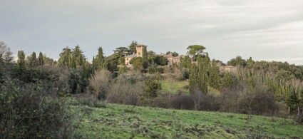
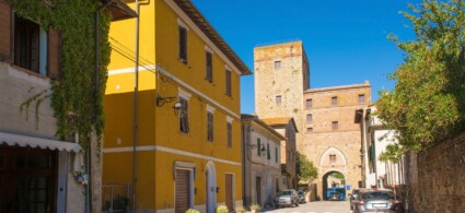
Built on a foundation of trachytic rock, Roccastrada enjoys an enviable position, a vantage point overlooking the Siena and Grosseto hillsides. The administrative centre of the municipal territory, the town rises to 475 metres, with a population of around 2,700 people. Around its historic centre, which preserves a fine church dating from the thirteenth century dedicated to San Nicola, new residential areas have developed, including the “Nuovo Centro”, built around the state road, where the quality of the buildings, the presence of car parks, rest areas and pedestrian passages, together with numerous shops and services, make this area the true urban hub of Roccastrada.
In this zone you’ll find the town hall with its library, a theatre dating from the nineteenth century (Teatro dei Concordi), a cinema (Cinema Massimo) and the large municipal park (Parco del Chiusone). Further south, at the base of the historic village, there’s a cluster of public services including a health clinic run by Local Health Authority No. 9, a geriatric institute and a vocational training centre. Set back from the town centre, though still accessible from the central Piazza Gramsci, is a sports and school complex (secondary school).
A centre of almost a thousand inhabitants, at 530 metres elevation, it has a well-preserved historic quarter, built on a rocky outcrop—a trachytic spur of Sassoforte—which constitutes much of its environmental appeal. The real functional hub is Via Roma, home to productive activities and services, along which much of the modern building complex has developed. The settlement is rather scattered along the provincial road until it merges with Sassofortino. Like other localities in the area, its isolated position atop the rocky summit allows for commanding views across the entire Grosseto plain. The woodland surrounding the area is perfect for relaxation and invigorating walks.
Just a few kilometres from Roccatederighi lies the village of Sassofortino, with almost 900 inhabitants, at an elevation of 570 metres. Of late medieval origin, following the abandonment of Sassoforte castle, it has experienced recent growth along the provincial road, with a marked difference between the older and newer parts. Further up, between the wooded area of Sassoforte and the more recent building zone, you’ll find Parco della Sorgente, notable for its environmental and urban design quality. Heading downhill from the village along a charming and steep lane (strada del Peruzzo), you’ll discover the Pieve di Caminino, an eleventh-century Romanesque church.
Famous for its fortress immortalised by Simone Martini in “Guidoriccio”, Montemassi is a small centre of almost 200 inhabitants, at an elevation of 280 metres. It’s currently undergoing a series of urban and architectural redevelopment works, within projects envisioned by the “Patto Territoriale per lo Sviluppo”. The area comprising the current Polifunzionale Centre (which will also become a documentation centre for the entire archaeological zone), the small Parco della Rimembranza and existing sports facilities is now conceived as an urban structure supporting cultural activities linked to the castle’s presence. Montemassi is also expanding along two directions, behind the small Madonna church and along the old section of the provincial road, lower down.
Positioned in the heart of the Monte Leoni area, the village enjoys extraordinary views that allow it to command the entire plain. Access from the lower plains is possible via a single road which itself boasts striking panoramic qualities. Now reduced to just a few dozen inhabitants, Sticciano (also known as Sticciano Alto to distinguish it from the village below along the railway) is a medieval settlement of considerable value, with a splendid twelfth-century church dedicated to the SS. Concezione and better known as Pieve di S. Mustiola.
A few kilometres from Torniella, you’ll find Piloni, home to around a hundred people, a recent settlement that in the early nineteenth-century Catasto Leopoldino was recorded as a cluster of just a few dwellings. It lacks a defined urban structure and was probably functioning as a workers’ village tied to woodland activities and stone working, as the name suggests, possibly synonymous with “monoliths” or “pillars”. In the small central square stands a tiny church built in 1819, dedicated to “S. Maria delle Grazie”.
Like Torniella, it has recently seen significant immigration from the former Yugoslavia (Bosnia and Macedonia), with workers engaged in seasonal woodland felling work.
The route begins at the hilltop known as “Battifolle”, a structure from within which the Sienese army conducted the siege of 1328, immortalised in Simone Martini’s celebrated fresco, though the attribution and dating of this work remain hotly debated among scholars today.
On the hill today, it is scarcely possible to imagine the position of the enormous siege machine, since the Sienese government itself ordered its demolition to prevent it from falling into enemy hands. The gently flattened summit of the hilltop is bounded on three sides by steep slopes that occasionally reveal fragments of ancient terracing walls.
To visit Montemassi, continue towards the village itself. From the car park situated below the fortress, climb by road to a cluster of houses that once formed the northern boundary of the village walls. At the end of the ascent, you’ll notice the remains of medieval fortifications on your right, including the foundations of a small rectangular tower—one of the few structures to survive the 1260 destruction ordered by Siena’s Ghibelline government. Leaving the road, climb a path carved into the living rock that leads to the cliff edge; from this exceptional vantage point, you can enjoy views down across the village’s modest dwellings, their terracotta roofs sloping towards the splendid countryside below. Retracing your steps, take the paved lanes to your right leading towards the historic centre. As you descend through the village, notice the heavy limestone projectiles scattered along the narrow streets—found in great numbers throughout the settlement, they’re either stacked in corners or arranged neatly outside houses.
The path leads to the present parish church of Sant’Andrea, situated on the southern slopes of the hilltop and aligned with the main thoroughfare of the southern fortress settlement. This religious building, heavily modified over time, shows construction phases from the fourteenth century—documented as initiated by Nello di Inghiramo Pannocchieschi—and preserves within it an interesting bronze bell from the years immediately following the Sienese conquest.
Having crossed the village and descended past its walls at a well-preserved stone gate, turn right and climb back up to the car park where your visit began, while above looms the fortress, ever-present on its verdant rocky outcrop.
By retracing the traditional places of worship, it’s possible to discover, through physical evidence, how the religious sensibilities of Montemassi’s community evolved over time. From the eleventh century onwards, the village’s history was intimately bound to that of the church of Sant’Andrea, built at the initiative of the Aldobrandeschi family, lords of the castle. The founders’ aim was to promote a parish church to replace the ancient baptismal church of Caminino, situated in the nearby countryside. According to local tradition, the spiritual heart of Montemassi’s territory was this church dedicated to San Genziano, where the faithful were baptised and received Christian burial. Over the course of two centuries, the Aldobrandeschi counts’ actions succeeded in displacing these ancient customs in favour of Montemassi’s church. The still-living veneration of San Feriolo represents the strongest expression of local resistance to this shift: the saint’s figure remained closely tied to the water source near Caminino church, which remains a destination today for processions from neighbouring and distant villages.
In the modern era, alongside the cult of Feriolo, revitalised by hermitic figures, more widespread forms of religious devotion developed, leading to the construction of new religious buildings, such as the church of the confraternity of San Sebastiano and the church of the Madonna delle Grazie—both held dear by populations afflicted by malaria and plague.
The itinerary begins at the church of the Madonna delle Grazie, a building with the typically modern form of a square-plan oratory, its façade characterised by a simple doorway flanked by windows and crowned by a small circular opening. The chapel is surrounded on three sides by a squat arcade with arches supported by sturdy brick pillars, built no earlier than the seventeenth century. The chapel’s upkeep was entrusted to the young women of the village, and the community gathered there to venerate a wooden panel painting of the Madonna.
The oratory likely occupied the site where a chapel dedicated to the Virgin had stood in the fourteenth century, erected at the foot of the hilltop where the 1328 battifolle had been built, and which, according to a still-living local tradition, arose precisely midway between Montemassi fortress and the Sienese camp—in other words, at the spot where the cessation of hostilities was supposedly agreed upon, erected as a votive offering for peace restored.
Following via del Capezzolo, you enter the village walls and reach piazza della Chiesa, from where a lane on your left leads up to the church of San Sebastiano. This religious building was constructed around 1590 at the initiative of a lay confraternity whose members wore white sackcloth cloaks on ritual occasions. Subsequently, the building was converted into a mortuary; in the nineteenth century it was reconsecrated, then deconsecrated again to become the headquarters of the Workers’ Society.
Returning to the piazza della Chiesa, the parish church of Sant’Andrea overlooks the square. The earliest record of this religious institution dates to the eleventh century, when it was dedicated to Santa Maria, Sant’Andrea the Apostle and San Genziano. We don’t know the original location of the church, which for a period occupied the hilltop plateau of Montemassi fortress, but we do know it was rebuilt at its present site around the early fourteenth century, at Nello Pannocchieschi’s initiative. As mentioned, the church now appears heavily altered, especially the façade, which results from the assembly of disparate decorative elements. The fourteenth-century church had a single-nave layout; in the modern era, lateral chapels were opened along its sides, originally dedicated to San Feriolo and San Sebastiano. The bell tower dates to 1762, as a plaque records, while the church’s roof was constructed between 1839 and 1845.
When your visit is complete, climb back towards the fortress to return to where the itinerary began.
The daily life of the village has left humble yet concrete traces, particularly from more recent periods, as Montemassi underwent profound transformations during the nineteenth and twentieth centuries.
Following the medieval flourishing of the settlement, Montemassi’s population was struck by various epidemics, so much so that by the mid-fifteenth century people lamented that “throughout the summer there are the most grievous illnesses from bad air and marsh fever”.
Until the threshold of the industrial revolution, the sparse population remained concentrated in the village, engaged in seasonal work on the lowland estates and the free-range rearing of pigs, goats and buffalo, whilst only from the eighteenth century onwards was sharecropping introduced with the creation of farms in the countryside. A further and more profound change in local society came with the opening of the coal mines at Ribolla, some four kilometres from Montemassi. Towards the end of the nineteenth century, the discovery of lignite deposits was accompanied by the construction of a railway to transport the coal, and extraction activities saw considerable growth, especially during wartime. Montemassi thus transformed into predominantly a working-class centre until the mining crisis began in 1948 and worsened catastrophically in 1954, when Ribolla witnessed a terrible mining disaster in which a firedamp explosion claimed 43 lives.
From piazza della Madonna, climb up to a group of houses that once formed the village’s ancient northern boundary. The first building on the left has a curious semicircular termination, created by a cylindrical tower inserted into the defensive walls. Inside it housed an olive mill, which preserves remains of ancient milling equipment: one of three “olive presses” present in Montemassi in the mid-seventeenth century, belonging respectively to the Marquis Malaspina, the Marquis Bichi and the rural commune.
From the ancient mill, descend through the village’s narrow lanes until you reach a terrace at the southern extremity of the settlement: from a horizon stretching to the sea, you can admire a splendid panorama of the countryside below, dotted with olive trees and bordered by groves of cork and holm oaks.
The descent continues through recently paved lanes using local volcanic stone; these are particularly narrow and steep streets that also struck the imagination of ancient visitors, who noted that “the roads resemble rather passages than streets, being short and narrow”. You walk between houses built largely from local materials and often from squared stones salvaged from medieval fortifications.
Taking one of the alleys, you reach the communal bread oven, crowned by a pointed arch still blackened by smoke; then climb back to the church of Sant’Andrea, facing which opens the village’s main square. Here, on the feast day of the saint, a fair was held, enlivened by “goods of all kinds and considerable crowds of people from neighbouring villages”. For the rest of the year, the square served as the community’s meeting place, where inhabitants also gathered to draw water from the public cistern below. Leaving the parish church behind, you reach piazza Salotto, where recent works have uncovered a smaller cistern, and climb a small flight of steps, passing beneath an arch built at the fortified wall, to observe on your left the grand palazzo of the Marquises Malaspina, feudal lords of Montemassi. In 1632, the Medici government granted the centre to Giovanni Cristofano Malaspina, who established his noble residence not on the fortress, as his predecessors had done, but within the village’s urban fabric, near the western extremity, so that the palazzo was accessible both from inside and outside the walls.
The route continues to the starting point via via del Capezzolo, passing through the suburb that grew up between the nineteenth and twentieth centuries to house the miners of Ribolla.
To see all the facilities and book accommodation in Roccastrada use the form below, entering the dates of your stay.
 Hotel
Hotel  Budget accommodations
  Apartments
  Family Hotel
 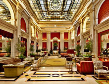 Luxury Hotel
  Resorts