
The meeting point is at Levigliani di Stazzema. You’ll reach it via Seravezza, Ruosina and Retignano, heading up the Torrente Vezza valley on the hydrographic right bank, following the Arni provincial road.
The village of Levigliani stretches across an orographic terrace at 600 m altitude, at the base of the imposing towering walls on the southern slope of Monte Corchia (1678 m). The tourist entrance to the Antro is over 2 km from the village. You’ll reach it in just a few minutes along a marble-paved road that climbs, with several hairpin bends, to an altitude of 860 m.
The artificial entrance to the Antro del Corchia has been created within an old marble extraction quarry. The connecting gallery appears almost like the natural underground continuation of the external marble excavation face.
The path climbs gently for almost 170 m in length, rising about 20 m in elevation. The depth of the artificial shaft isn’t fully perceptible due to three successive doors that separate segments of the gallery, sealing it “airtight”. This controls air flow exchanges between the external and internal environments.
Upon entering the karst cavity, you’ll leave on your right a squat conical stalagmite formation called “Il Gendarme”. Progress through the Antro is facilitated by walkways in the form of bridges, ramps and steel steps, which have also minimised the transformation of the karst environment caused by tourism, especially as they prevent contact with the cave floor.
With a 37 m descent and 212 steps, the route immediately tackles a challenging descent along the “Galleria Franosa”. The middle section consists of a single impressive narrow chamber over 30 m high, with a width never exceeding 4 m, narrowing down to 150 cm. This area had a complex origin from a large vertical fracture, whose walls today appear rather undulating, sometimes with wide and deep sub-horizontal incisions.
The “Galleria Franosa” ends at 843 m in a widening with conglomerate deposits on the ceiling, where the “Galleria degli Inglesi” and the entrance to “Pozzo Suzanne” almost simultaneously begin.
The “Galleria degli Inglesi” has an overall length of 245 m in its equipped section and belongs to a network of rectilinear, horizontal and overlaid conduits, originating from a single sub-vertical fracture plane that underwent further enlargement through chemical and mechanical processes. The two main galleries of the network are separate, but several communication points exist along the route. These vertical connections become increasingly evident from the midway point onwards, with the Antro’s ceiling rising to reveal the upper conduits. It’s precisely here that the “Galleria degli Inglesi” is often interrupted by small drops, sometimes formed by chaos of blocks that have fallen from above.
Along this section of the route, the cave walls are covered in scallops (small regular concavities, also called “gouge marks”), of varying sizes, which are the result of past turbulent underground water flows.
At the end of the “Galleria degli Inglesi”, on the left, a small cascade plunges down a high shaft, carving the wall with broad grooves. The equipped route, reaching 859 m, avoids continuing straight ahead towards the “Risalita dei Romani”.
It turns right instead to find the entrance to the “Galleria del Venerdì”, through a tight passage that opens onto the opposite side.
The “Galleria del Venerdì” is 261 m long and entirely of phreatic origin. About a third of the way along, as the conduit turns left, the opposite wall offers an imposing flowstone formation that simulates the shape of an eagle with wings ready for flight. Nearby, a stalagmitic alcove, supported by a limestone column, has been named “Capanna trogloditica” (troglodytic hut).
After around 75 m, you’ll reach the “Laghetto del Venerdì”. The waters are shallow but must be crossed by a bridge resting on the opposite sandy bank. This small space has always been a frequented stopping point for speleologists, judging by the countless inscriptions crowding the nearby walls.
Coralloids of the Petrified Forest A narrow and deep gorge is reached, into which the waters of a small stream flow, then continuing to the right into the “Pozzo della Gronda” or “della Cascata”. This is the origin of that long descending branch of the Antro del Corchia, which eventually ends on the bottom at around 450 m altitude.
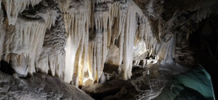
The signage suggests going right, which penetrates more easily into the evocative “Galleria delle Stalattiti”. There’s a sort of vestibule to cross, also concretioned though now almost entirely fossilised. It’s the “Petrified Forest” that stands before you, with stalactites and stalagmites with bulging forms and grey-brown earth colouring. Water no longer flows here and scarcely a drop vivifies the formations, which are so dense they almost obstruct the path. The walkways advance carefully through this stiffened, dusty world, zigzagging in all directions. At the furthest point of penetration into the Antro del Corchia, the wall seeps with water from the active phreatic levels beyond.
A large collapse boulder, with a phallic stalagmite above it, serves as the lintel to the entrance to the still “living” section of the “Galleria delle Stalattiti”. Speleologist Jean-Carlo Fait described the place as an oasis of rare beauty amid a world of stone, mud and water. These are environments of intense fascination, to which few underground chambers in the world can still compare today.
Describing what meets the eye is difficult due to the richness of colours and variety of forms that have originated here. The formations crowd against one another, descend along the walls and plunge into small pools of clear water. The stone lace of some calcite fans displays the alternation of coloured layers. The stalactite drapery brushes against a stalagmite covered in limestone nodules. In the background, a single pillar seems to support the vault of this place of aesthetic sublimation.
Active stalagmites The “Galleria delle Stalattiti” is a typical phreatic conduit, at an average altitude of 871 m, where carbonate precipitation is still active. Here too the equipped route has adapted to penetrate respectfully amongst the formations. At the end, you continue for a brief descending stretch, crossed by a cascading stream with collapse boulders restricting the way. Then the route becomes level and easy again.
We’re back at the closing point of the final loop. On the left, the possibility of revisiting the eden of the “Stalattiti”; on the right, the return to earthly matters.

 Hotel
Hotel  Budget accommodations
  Apartments
  Family Hotel
  Luxury Hotel
  Resorts