Agriturismo Il Calesse
Quarrata - Via Carraia, 215
Book now

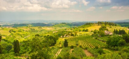
The territory of the municipality of Quarrata covers 46 square kilometres, stretching from the north-eastern slopes of Montalbano down to the plains watered by the River Ombrone. Originally part of the Tizzana grand-ducal podesteria, Quarrata became the municipal capital in 1888, though the municipality continued to be named Tizzana until 1959. Today Quarrata is an important industrial hub, particularly in the furniture sector, which focuses almost exclusively on the manufacture of upholstered and covered furniture. More recently, the processing of rubber and expanded resins for upholstery has also developed significantly.
Of particular artistic interest are Villa La Magia, recently acquired by the municipality, the Church of S. Michele Arcangelo at Vignole, the medieval village of Tizzana, the Church of S. Michele Arcangelo at Buriano, and the Church of S. Maria Assunta.
Local tradition holds that the hamlet’s name derives from a certain Monna Ferruccia who, in her will dated 7 December 1385, expressed her wish to be buried in the church of SS. Filippo and Iacopo, thereafter known as “Santo di Monna Ferruccia”. The Church of SS. Filippo and Giacomo, documented from 1383, was elevated to the status of a pieve in 1648. Rebuilt around the second half of the 17th century, it underwent further significant alterations in the 19th century, when it was substantially enlarged. In the vicarage rooms, a Museum of Sacred Art will be set up, displaying artworks from the surrounding territory dating from the 17th and 18th centuries. In the Ferruccia hamlet, according to an ancient tradition, the “Feast of S. Antonio Abate”, patron saint of animals, is celebrated each January with the blessing of animals and the distribution of blessed bread by means of a late-18th-century wagon drawn by a pair of oxen.
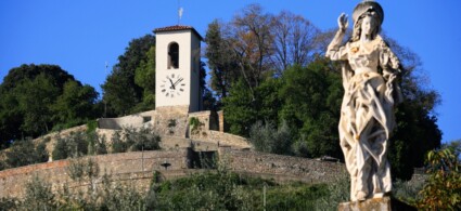
The locality is documented from 1016 as a settlement of “Lambardi” or “Longobardi” peoples. There are no certain records of the Church of San Michele before the 13th century, when it appears registered as being under the jurisdiction of the Pieve of Montemagno. The medieval structures of the church were entirely obliterated by 18th-century refurbishments and numerous restoration works carried out over time, the most recent dating from 1893. The bell tower is particularly striking, with a square base dating to the mid-15th century and built entirely in terracotta. The building, preceded by a five-bay portico, features a single barrel-vaulted interior: noteworthy are the 18th-century high altar, a large canvas depicting San Michele Arcangelo, and the organ housed in the priory, built by Pietro Agati in 1797, recently restored and considered among Pistoia’s historic organs. For about two decades, the church has been closed for worship, with services currently held in the adjacent newly constructed church.
Situated on the slopes of Montalbano at an altitude of 182 metres above sea level, its history closely resembles that of Buriano, as it was the site of a fortress belonging to the Cadolingi counts of Fucecchio, which existed before the year 1000. In the 12th century it formed part of the possessions of the Bishops of Pistoia and later passed to the Panciatichi family: it was here that the Ghibelline Astancollo Panciaticki sought refuge following the Battle of Benevento in 1267, before being forced to flee after the stronghold was captured and destroyed by the Guelph Cialdo Cancellieri, Podestà of Pistoia. The present church and the former nursery attached to it stand within the perimeter of what was once the ancient fortress. The name Lucciano is renowned for the wine production of the Conti Spalletti estate, which also promoted the spread of filet embroidery in the area. The estate building presents itself as an imposing and austere structure, set within a landscape of olive groves: its current appearance is the result of radical renovations carried out in the 19th century.
The name recalls a Latin property, probably derived from the personal name Burius: according to some scholars, it represents the Latinisation of the Ligurian hydronym Bura. It is a hillside hamlet situated mid-way on the eastern slope of Montalbano (201 metres above sea level). The settlement originated from a fortress perhaps already in existence during the Lombard period, which was owned by the Cadolingi Counts, then the Guidi and the Bishops of Pistoia, before eventually coming under the jurisdiction of the Municipality of Pistoia. Remains of the medieval structures are visible in the fabric of the Church of San Michele itself, and even more so in the vicarage, where the massive stone walls of a square-shaped tower emerge. A fanciful reconstruction of the castle walls was created by the parish priest, who arranged fifteen shrine chapels of the Via Crucis along the route.
The name has Latin origins, according to some derived from “monte” (mountain) and “Oro” (gold) in the sense of rich and fertile, possibly also referring to mica-rich rocks, though more plausibly it combines “mon(te)” and “toro”, which in Latin means a rise in the land, a rounded hill, and later also a fortress. Before entering the village, you encounter the 17th-century villa of the Baldi Papini family, belonging to an ancient family of Pistoia landowners. The Church of San Martino, documented from the 13th century as being under the jurisdiction of the pieve of Quarrata, is now a small oratory: despite numerous alterations, it retains much of its Romanesque structure and, between 1950 and 1960, was entirely frescoed by painter Azelio Tuci.
A Latin name, composed of the noun “monte” (mountain) and the adjective “magnus” (great). It is worth noting that in the village area another toponym appears, “podere Columella”, which recalls the Latin columna and perhaps, like the toponyms Colonna and Colonnata frequent in the Florentine plain, marks a boundary of Roman land division. The “Atlas of Archaeological Sites in Tuscany” (1992) records the discovery in the Montemagno area of prehistoric stone artefacts and fragments of Roman pottery. The locality of Montemagno, documented in the 11th century, extends across a spur of Montalbano between Quarrata and Casalguidi. On the hilltop, where only the pieve now stands, there once rose a castle of which no traces remain except in historical sources: Repetti (1839) recalls the presence of a podestà in the 14th century.
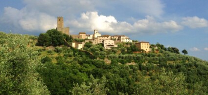
The medieval village is perched, with its oldest nucleus, on the ridge of one of the extreme north-eastern spurs of Montalbano. The original nucleus is likely to be very ancient: the “Atlas of Archaeological Sites in Tuscany” (1992) records the discovery at Tizzana, in an unspecified area, of remains of Roman structures not yet identified, which could confirm the probable Roman foundation of the site. The first historical record of Tizzana dates back to 1034 and is contained in the “Libro Croce”: the Tizzana castle was then the possession of the nobleman Rodolfo di Pietro. Having freed itself from feudal bonds, in 1240 Tizzana became a free municipality and, divided into four districts, each with its own church, administered a vast region.
The Municipality of Tizzana gradually lost its importance, while Quarrata gained it, officially becoming the municipal capital in 1959. Of the ancient castle structures – walls, keep and towers – only a few remnants survive today: some traces of the defensive wall remain around the archway of the main gate, where several coats of arms of local Podestà are still visible. From the gate you access the piazza, the heart of the village, at whose edges stands the Pieve of San Bartolomeo, built at the same time as the fortress and flanked by the bell tower, originally one of the castle’s guard towers. Beside the gate stands the former palazzo of the podestà, later the seat of the Municipality of Tizzana and now a private residence. Where the fortress once stood, behind the palazzo podestarile, there is now a hanging garden. The ancient castle probably had a triple ring of walls, the outermost of which circled the base of the hill, as confirmed by the toponym “Santallemura”.
Notable is the Church of SS. Maria and Clemente, of ancient foundation mentioned in the memorial of Bishop Ildebrando of 1132. Dependent on the pieve of Montemagno from the 13th century, it acquired its dual dedication following the parochial visitation of 1541. The building was completely refurbished in the 19th century and of the ancient structures only the bell tower remains. Worth noting: Villa Zaccanti, a venue for meetings and receptions, and the “Carnevale Rio de Valenzatico” event, featuring allegorical floats created by the village wards.
It rises at the foot of the Montemagno hill: here you find the lake of the same name surrounded by century-old oaks and pines. In the early years of the 14th century, there was already a church in the area called “Santa Maria Novella”, while the toponym “Santonuovo” appears for the first time in a document of 1444. In the 16th century, the Banchieri family held the patronage of the oratory: only later was a new parish built, separated from that of Montemagno, thus giving rise to the Church of San Germano with the permission of Grand Duke Pietro Leopoldo. The religious building was consecrated in 1785: inside, a single nave, note the high altar of 16th-century form, dating from the time of the church’s foundation.
Outside the building, behind the apse, in 1794 an oratory was erected for use by the Confraternity of the Blessed Sacrament: following the suppression of the Company, the building lost its original sacred character. Worth noting in the hamlet is the presence of the “Pinguino” airfield, a reference point for enthusiasts and athletes who enjoy practising air sports on hang-gliders and microlights or who wish to obtain first and second-degree aeronautical licences. Also worth noting is the Church of Santo Stefano, in the Campiglio locality, which stands immediately outside the road running from Santonuovo to Quarrata: the church, whose first historical record dates back to 1321, is remembered as suffraganean to the pieve of Montemagno. Of probable Romanesque origin, as evidenced by some sandstone ashlar blocks brought to light near the vicarage, the present building is the result of modifications from the second half of the 17th century.
Worth noting is the Church of the Sacred Heart of Jesus, a recent construction situated along the Via Statale Fiorentina, opened for worship in 1957 to replace the ancient parish seat of San Biagio. The church was built to a design by Florentine architect Alfonso Stochetti.
To see all the facilities and book accommodation in Quarrata use the form below, entering the dates of your stay.
 Hotel
Hotel  Budget accommodations
  Apartments
  Family Hotel
  Luxury Hotel
  Resorts