Florence: Uffizi Timed Ticket & Masterpieces Audio App
7.148 reviews
Buy now
From 27,20€ per person

During the Middle Ages, the Via Francigena or Romea represented the principal pilgrimage route to the holy cities of Christendom: Rome and Jerusalem. Pilgrims could stop in Rome at the tombs of Saints Peter and Paul, or continue along the ancient Appian Way to the ports of Puglia, where they could embark for Jerusalem. To the north, beyond the Alps, the Francigena connected with the Via Tolosana, which led to Santiago de Compostela, where the reliquary of Saint James the Apostle held great appeal for pilgrims from across Europe. Kings, popes and princes travelled this important medieval route alongside humble penitent pilgrims.
Eleventh-century Crusaders also followed this direction in their quest to reclaim the Holy Sepulchre of Christ. The Francigena road served as a privileged channel for both cultural and commercial exchange. Merchants travelled it to reach major trade fairs, such as those in Champagne and Flanders, where precious Luccan silks were highly sought after. Along the Francigena route, villages, castles, monasteries and especially hospitals or hospices for the aid of travellers flourished.
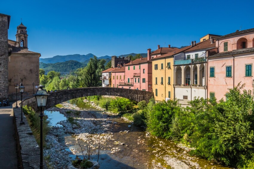
Tuscany is undoubtedly one of Italy’s regions most favoured by this important thoroughfare, and today it still preserves clear traces of it in the numerous Romanesque architectural remains and the unspoilt landscapes of much of the territory it passes through.
The Via Francigena is a network of roads and paths that has been travelled by pilgrims since ancient times to reach Rome. Originating from French territories, from which it takes its name, it now officially identifies the route from Canterbury to Rome, based on the testimony left by Bishop Sigeric in the year 980. The Tuscan stretch, spanning 394 kilometres, starts at the Passo della Cisa and enters Lazio at Ponte a Rigo, passing through particularly beautiful territories and important cities, some of which were founded and developed thanks to this Via.
The Via Francigena is a route that uses, from current road networks, both paved roads, cart tracks and paths. Some of the chosen roads are hazardous due to vehicle traffic, forcing walkers to concentrate on the road and losing contact with the surrounding nature. For this reason, local variants are being identified using paths, mule tracks or secondary paved roads, although this implies extending the journey—it will be up to the pilgrim to choose their preferred solution. To walk the variants, you need to download the relevant maps or GPS tracks, as they have not yet been marked on the ground. The connections allow you to reach notable points from the Francigena, such as churches or hospices.
In ancient times, Tuscany was crossed by a network of roads travelled by pilgrims, armies and merchants. We have sought to identify some of these routes and highlight them with the intention of finding connections with the official Via Francigena.
In particular, the aim is to identify other pilgrimage routes that came from other European countries, such as the Via Bibulca, for example.
The credential is the pilgrim’s document. With this card, you can see recorded a plan, a starting point, a destination, the passages through villages with stamps that can be collected at hospices, communes or churches.
The documentation registered serves also to obtain, if desired, a document testifying that the pilgrimage has taken place; at Santiago it is called the Compostela and in Rome the Testimonium.
It should be noted that the figure of the pilgrim is not recognised exclusively in those who travel such distances guided by devotion and the desire to reach a sanctuary so important to their faith; one can be a pilgrim in many ways, and this is easily observed by frequenting pilgrimage routes.
The reason why pilgrimage, religion aside, becomes something one might call sacred for everyone is both simple and mysterious.
Pilgrims heading to Rome who wish to prioritise Tuscany can start their journey from Berceto. Easily accessible by train on the Parma–Genoa line, it’s possible to arrive on the morning of departure; alternatively, arriving in the evening, pilgrims can request hospitality at the Capuchin Friars’ convent, which has welcomed many pilgrims over the years and will undoubtedly continue to do so.
Indeed, as the ‘Stage Point’ sign in front of the Tourist Office readily attests, this is one of the locations recorded and mentioned in many famous pilgrimages, the earliest being that of the Bishop of Canterbury, the renowned Sigerico. As successor to Edelgardo in the London see, he travelled to Rome to receive the ‘pallium’ from the Pope and took care to recount his return journey, thus providing an established itinerary. The “pallium” was the white stole reserved for Popes and Metropolitan Bishops, which conferred authority over other English bishops.
Today much research has been conducted to establish exactly where this bishop passed through, resulting in differing opinions despite clear testimony. However, since a road becomes sacred not merely because it was trodden by a bishop—soldiers, merchants and brigands before and after him have also worn it smooth for better or worse—we shall trace a route that serves best for reaching Rome in modern times and undertaking our pilgrimage by holding sacred first our intention and second our desire to admire and then understand and delve into the history of these places. The Tuscan territory is so rich in documents and beauty that it merits traversing on more than just a pilgrim’s feet.
Setting out from Berceto, the pilgrim will find the Cathedral, where they can have their credential stamped. In visiting this magnificent duomo, they can benefit from another form of commission: on the lateral portal, two caryatids from 1198 represent Saints Peter and Paul, and in these one can recognise the indication and invitation to pilgrimage. A perfect beginning, indeed!
Yet looking carefully, one can find another important symbol: a caryatid on the Cathedral portal—a pre-Antique sculpture, attributed to the twelfth century—depicts ‘Labour’; the pilgrim can gaze upon it to draw strength and encouragement for the moments of crisis they will encounter on their path, and since it is also remarkably beautiful, its efficacy is assured.
The pilgrimage begins with ease; the route is well marked by arrows and reaches Pontremoli, which could serve as the first stage, presenting no difficulty.
Roughly midway, the pilgrim arrives at Passo della Cisa, and as clearly indicated by an ANAS sign, their journey is now officially in the Tuscan region.
At the pass, little frequented since the motorway replaced this ancient route, there is an excellent refreshment point—a bar selling local products including honey, biscuits and cheese. There is a small church (00030) atop a flight of steps, as befits such a significant territorial point at a border, and a couple of tourist shops, for sometimes the pilgrim becomes a tourist, and sometimes the tourist becomes a pilgrim.
The ancient passage of the Via Romea was nearby, at a point 1,039 metres in altitude simply called Monte. This natural pass was the most frequently used in medieval times to enter Tuscany and remained so for many centuries, offering relatively easy passage not only on foot but also for pack and riding animals.
Beyond the pass, the road reaches Montelungo Mons Langobardorum, an ancient location that certainly provided pilgrim hospitality, as it once housed a monastery dedicated to San Benedetto under the direct jurisdiction of Bobbio Abbey—another place of hospitality the pilgrim might have encountered had their pilgrimage begun further north.
Perhaps this is the monastery mentioned in the Anglo-Saxon Chronicles: “Hoc Tempore (596) monasterium Benedicti a Longobardis destructum est”.
Between 900 and 904, the Bishop of Canterbury, Sigerico, recorded the places where he stopped on his return from Rome. This was his thirty-second stage: Sce Benedicte XXXII
After him, around 1154, another cleric on pilgrimage to Rome, travelling from Iceland, Abbot Nikulas of Munkathvera, crossed Monte Bardone and noted it as ‘Mumbard’.
Heading towards France, Philip Augustus in 1191 on his return from the Third Crusade, passing through ‘Punt-Tremble’ and ‘Munt-Bardum’, noted that ‘ibi deficit Tuscana et incipit Italia’.
And many others before and after them, leaving testimony or not, kept this route alive, enriching it with history and tradition that would accompany even the loneliest pilgrim.
The Magra river marks the path and accompanies the pilgrim to its mouth near Santo Stefano.
A peaceful town at the heart of Lunigiana, sensitive and active in its contemporary cultural life and its tradition as a stopping point on the Via Francigena, it is indeed Sigerico’s Puntremel XXXI.
Located on the Parma–Genoa railway line, the station is in close proximity to the historic centre. The town’s name is believed to derive from an ancient wooden bridge, ‘Pons Tremulus’, which, however precarious, allowed passage across the river. Rich in history since its founding by King Enzo of Sweden in 1247, Pontremoli protected its strategic position with a defensive system based on natural barriers and the confluence of waterways—the Verde and Magra rivers—and carefully designed fortifications. Its elongated structure runs from Porta a Parma, crosses the two central piazzas separated by the Torre del Campanone, where in 1322 Castruccio Castracani operated a barrier to keep the city divided and prevent clashes between Guelphs and Ghibellines.
There is a tale of another rather particular but undoubtedly effective defensive system for those concerned with such matters: an inscription on a bell in the Church of San Francesco, cast by one Ilario in 1313, claims its tolling has the power to drive away evil spirits. In those times such precautions were greatly appreciated.
Elsewhere in Lunigiana, another bell, another church, San Cristoforo, bears the inscription “MCCCIII, ne mentes ledant, fantasmata cuncta recedano”—the idea of banishing ghosts in a rather solitary valley had its reassuring effect.
The oldest of Pontremoli’s bridges is called Cresa, built in a humpback style like many others the pilgrim may have already encountered not only in Italy; it spans the Verde river in the upper part of town. The Stemma or Busticca bridge is located lower, near where the Magra meets the river.
The Rocca-museum, Castello del Piagnaro, houses stone slabs and funerary stelae bearing stylised human features, possibly depictions of Celtic warriors found in various places throughout Lunigiana—fascinating relics of history even older than that of pilgrimage.
The climb to the castle is well rewarded by splendid views. Just beyond the entrance stands the small church of Sant’Ilario, whose façade dates from the last century, though its choir area features a semicircular apse revealing other elegance and earlier origins—perhaps a place of pilgrim hospitality. From that point, another path branches off northwards, one of the many branches of the Via Francigena, perhaps older than the one our pilgrim follows, connecting the town to Borgo Taro.
The convent of San Francesco, of medieval construction with little remaining, is said by tradition to have been built after Saint Francis’s passage in 1219.
Near Porta a Parma stands the Romanesque church of San Giorgio, its origins dating to the tenth century. We should also mention the Church of San Giacomo di Altopascio, now a school, built in 1508 on the site of an ancient hospital—its very name seems to testify to this.
It is said that Barbarossa showed his son the city of Pontremoli as the key to entering Tuscany.
Should the pilgrim be fortunate enough to arrive on a holy day of obligation, the Church of San Pietro, open for religious services, offers a magnificent bas-relief depicting the ‘labyrinth’—a widespread symbol found on pilgrimage routes signifying all that can conceal or represent a labyrinth, perhaps including the difficult search for a path both physical and spiritual.
The pilgrim encounters Pieve di Sorano, in the municipality of Filattiera, shortly after leaving Pontremoli, in the valley bottom on the left bank of the Magra river; visitors-tourists can also reach it easily on the Statale 62 della Cisa at the 30 km mark, or by stopping at Filattiera railway station on the Parma–La Spezia line.
The church was recently restored, thus preserving a site bearing witness to a long and precious history, of which significant remains have been found throughout the surrounding area. The territory was already populated during the Copper Age and preserves Roman remains from the third century AD. Like all the Luni territory of which it is part, its life has passed through periods of alternating fortune.
It is believed that the church’s original construction occurred during a period of relative peace and security when the Luni territory was under Byzantine rule. It was dedicated to Santo Stefano, the first Christian martyr, yet the pre-existing building upon which it was placed had been a pagan place of worship.
The first mention of the ‘plebs de Sorano’ appears in a bull dated 11 November 1148, renewing the pieve’s possession to the Bishop of Luni. By that date the church already had its present structure in both appearance and dimensions, yet over the centuries it risked total destruction several times. The adjacent cemetery proved a lifeline; important families from the area created private chapels within the church itself and, caring for them, helped save it from complete abandonment.
After restoration was completed, Don Antonio, parish priest of Filattiera, wished to verify the truth of a popular tale claiming the pieve has crooked eyes. Indeed, on the days of solstice and equinox, sunlight enters respectively through the right opening in December, the central one in March, and the left opening in June. Its builders structured it so it could signal the passage of seasons to the population, thus also calculating liturgical dates such as Easter, which are determined by these. Such particular designs are common in ancient constructions; the pilgrim on the Santiago de Compostela route who has stopped at San Juan de Ortega will already have heard a similar story and will be pleased to hear this one too.
At the 31 km mark of the Statale della Cisa sits this town, whose oldest nucleus lies in the elevated area: there a round tower testifies to its Byzantine past and the origin of its name.
In the church, S. Maria in Filattiera, a white marble baptistery is preserved, a work created in 1605 with a beautiful base bearing sculptures and the Florentine lily; it comes from Pieve di Sorano, which by that period was almost entirely abandoned, so the parish sought to gather the surviving furnishings and bring them within the walls.
From the same provenance is a white marble statue, over a metre tall, of San Giacomo.
Far more important as testimony to pilgrim passage through this area is a plaque preserved in the Church of San Giorgio. The inscription commemorates one Leodgar, who died in 752, a missionary who not only created a place of welcome and assistance for pilgrims but also merited the conversion of many valley inhabitants to Christianity by ‘breaking pagan idols’. Yet another witness to the pilgrim world is a small bas-relief of San Giacomo encountered while crossing the town above the door of a house that was once a hostel, then a nursery, and is now a private residence. The owner holds it in great respect and care.
The town also has its own ancient and particular tradition celebrated each year on the feast of San Antonio: a great bonfire is lit in the square and the inhabitants vie to carry away a burning brand, which will be their protection from all ills.
The pilgrim entering here, even without closing their eyes, can feel transported to that distant time when this fortified hamlet (00080) in the valley bottom was in full activity. Looking around, one could believe oneself to have entered a film; the background music is absent but the pilgrim is accustomed to silence by now. This is one of those walled villages born from the struggle between the Byzantine army and the Lombards who invaded Lunigiana during the sixth and seventh centuries and has maintained its entire character. In the large square where the pilgrim finds a fountain (an encounter increasingly rare today).
one can identify the village’s matrix—a quadrilateral measuring sixty metres with a single means of access. In the Middle Ages, expansion occurred from the western side, whilst maintaining the quadrilateral design, forming those narrow internal streets characteristic of Lunigiana’s historic centres, the so-called ‘borghi voltati’. In the sixteenth century the walls were also extended eastward and two monumental gates were erected. A definitive restructuring occurred at the end of that century under new owners, the Marquises Ariberti of Cremona, who built their palazzo and the convent of the hospitalier friars of San Giovanni di Dio.
Each August a medieval re-enactment takes place with costumed participants and shops and stalls in the open showing ancient crafts; the effect in this setting must surely be quite evocative.
Villafranca Lunigiana is a medieval village that arose along the route of the Via Romea, which passed directly through the marketplace. Appreciable traces remain of the original building fabric and walls of the Malaspina castle of Malnido.
This castle, originally a castrum cum curia, has been documented since 1100, and its name likely derives from the onerous toll that the castle owner imposed on those passing through. The pivotal point where travellers could be stopped – including pilgrims – was the Roman bridge spanning the River Bagnone where it meets the Magra. Close to the bridge stands the Church of San Giovanni Battista, which today conceals within its current structure what was once a fourteenth-century building.
However, the village’s origins in the early medieval period appear to stem from a sudden population increase, drawn by devotion to the pieve dedicated to San Cassiano.
The entire area surrounding Villafranca bears witness to a rich and significant past, as evidenced by its villages, strongholds and castle ruins. One of these, at Malgrate, takes pride in displaying a medieval tower considered among Italy’s finest. It has been suggested that the area’s name derives from the presence of numerous diverse properties and lordships, all free from feudal constraints.
A visit to the Lunigiana Ethnographic Museum would certainly be worthwhile, and in the Church of San Francesco you can admire large terracotta works of the Della Robbia school, which are both interesting and beautiful. We should also mention the Church of San Nicolò, with the nearby Hospital of Sant’Antonio Abate and its splendid bell tower.
The pilgrim now has before them – though in this case would need to ford the Magra – an alternative with significant historical importance: they could take the road leading to the Chiesaccia, where a hospice attached to the Church of Santa Maria di Arbaritulo existed in the ninth century, a place mentioned by the abbess Níkulas.
Continuing along that route, near Fornoli, stood Santa Maria di Groppofosco with its chapel and hospitality centre, another stopping place and refuge for pilgrims and travellers near the ford that ferried people across to the right bank of the river.
Crossing the Roman bridge, you arrive at this castle, one of many Malaspina strongholds in Lunigiana, perched on a modest rise overlooking the Magra. It is a highly significant early medieval structure, built to defend the settlement and the routes through it. The building was destroyed in the fifteenth century and rebuilt in the sixteenth. Entry is through a gate jealously guarded by what appears to be an original key, opening onto a trapezoid courtyard with a well at its centre. The vertical structures are built from river sandstone; many sections still await restoration, though considerable commitment has already been made for the future. Inside, a Museum of Tuscan Emigration has been created, visitable by appointment.
The castle has excellent potential for development, particularly for creating accommodation for pilgrims, and we remain hopeful.
Beside the castle runs the village; as the pilgrim passes through it, those on longer journeys may recall similar passages through other settlements, with their entrance and exit gates creating a sense of shared belonging.
At the confluence of the Magra river with the Aulella stream, on the SS63, boasting an important railway station, Aulla is easily reached.
The pilgrim can identify it by the square mass of the Rocca known as ‘La Brunella’, which has stood there controlling the town’s entrance since the sixteenth century and will be spotted by anyone arriving.
Aulla was contested territory between the bishops of Luni and the Malaspina.
The Abbey of San Caprasio was founded in 884, commissioned by the marquis Adalberto, son of the Count of Lucca. Nothing remains of the original construction, as it was rebuilt in the eleventh century as a basilica; however, since only some external elements survive from this too, the church we can visit today retains only echoes of its precious origins.
This is the thirtieth location, the Aguilla XXX of Sigeric’s journey.
A little further south lies the village of Bibula with its distinctive spiral structure and the remains of a substantial castle built in the medieval period on an earlier Romanesque foundation.
This commune, currently in the province of La Spezia, once belonged to distant Luni, then to Genoa, Milan, and in the nineteenth century also to Massa-Carrara; it was an important communications hub just as it had been in the early medieval period. Indeed, in 981 Otto II declared it a market town by diploma, and Frederick I in 1185 more specifically: burgum cum mercatu, banno iustitia distictu piscationibus. In 1468 Santo Stefano was recognised as a fortified village and important bastion on a ford across the Magra.
On a small hillock the pilgrim may recall Sigeric’s next stage, Sce Stephane XXIX, but looking around will find that this entire territory is rich in historical architecture.
The village preserves sections of its medieval walls, and the Castle, once belonging to the Malaspina and the bishops of Luni, now converted into a school, hopefully thus protected by the world of culture. The Church dedicated to Santo Stefano has its foundations on the medieval pieve.
The village was not only a meeting point for pilgrims arriving from the valley and mountain routes, but also had a port at Bocca di Magra, San Maurizio, from which those wishing to reach Spain and Galicia departed by sea.
Here the pilgrim leaves the Magra river, this river born in the Apennines in the Tuscan-Emilian massif, rising in a beech forest on the Borgognone plateau at 1166 metres, forms part of our history.
It has been important since the earliest pilgrims could use its waters, yet equally feared and crossed, sometimes with courage and risk, for its passage; the ford near Caprigliola is famous for the considerable number of pilgrims who drowned there in the fourteenth century.
Unlike the typical Ligurian streams with their short, rapid courses, this river, by virtue of its width, flows slowly and for a long distance, hence its name (cf. Greek macros, long, and Latin macer), and runs for 63 kilometres through Lunigiana until it reaches the Ligurian Sea.
In past centuries the river has changed its lower course several times; in the medieval period it ran much closer to Sarzana, and even earlier it marked the boundary between Italy and Gaul.
Now the river approaches its destination, the estuary draws near whilst the pilgrim continues on their way.
We draw closer to the sea as the Monte Bardone route joins the Via Aurelia near Sarzana. This charming town was originally a rural pieve and owes its development to the decline of Luni. Indeed, in 1204, when the Bishops of Luni were forced to abandon their territory, which had become unhealthy, they transferred their seat here, bringing with them their precious relics and the crucifix by Master Guglielmo, which they placed in the Pieve of Sant’Andrea. This crucifix, painted on canvas and applied to a panel, dated from 1138, and is particularly significant as it is the oldest known example of painting executed in this manner.
The cathedral was built around 1300. It has a façade clad in white marble in Romanesque-Gothic style, with a bell tower adorned with bifores, trifores and quadriforums, built later and completed in 1432. Inside, among other works, is preserved the painting by Domenico Fiasella ‘The Glory of the Most Precious Blood’ in the reliquary chapel. Behind this canvas is the phial which, according to tradition, contains some drops of the blood of Jesus.
The bishops coming from Luni played a significant role in this territory and exercised their rule for over a century; subsequently, disputes over possession of the city arose between Pisa and Lucca, Florence and Milan, and finally Sarzana became part of the Genoese Republic in 1572, remaining a Ligurian province to this day. The city preserves its Genoese walls with the Porta Nuova and a fortification, La Cittadella, built on an earlier existing fortress, at the behest of Lorenzo the Magnificent when he arrived in the city in 1487. But dominating the city from a commanding position outside the urban centre is the fortress of Sarzanello, commissioned instead by Castruccio Castracani in 1322, an image dear to its inhabitants as a testament to a glorious past.
But at this point the pilgrim may have other encounters. Should they have undertaken the journey alone, they would welcome finding a travelling companion, even if only to share part of the way.
From the coast arrive pilgrims following the Via Tolesana; pilgrims coming from Santiago de Compostela, devotees of the Apostle James whose tomb was discovered around the year 1000 at the place where the great cathedral was subsequently built. Not all pilgrims can fulfil their desire to reach all pilgrimage destinations, so these meetings are of great interest and constitute a rich source of information about places of worship. The meeting between pilgrims is one of the most precious aspects of a pilgrimage; many people whose names or faces one sometimes cannot recall (though nowadays we make extensive use of cameras) have the capacity to touch one’s emotions and remain there forever: it will be wonderful to meet here too the pilgrim with whom to join the journey through Tuscany towards Rome.
These pilgrims from different countries were often called ‘Scots’ in Tuscany, as if they all came from Scotland. San Terenzo, who gave his name to the Ligurian port in these parts, was called a ‘Scot’, as were San Bianco and San Pellegrino, of whom it is told that they arrived as pilgrims and both lived as hermits, finding shelter in the hollow of a beech tree on the Alpe di San Pellegrino.
Luni was founded by the Romans in 177 BC. Its territory was crescent-shaped and it has been suggested that the name derives from this shape, which evokes the moon, and from its dedication to the pagan goddess. It was of great importance at that time, and it is said that its white walls could be seen from the sea. Its first destruction came in 642 with occupation by the Lombards.
In the time of our ancient pilgrims, Luni still stood by the sea; it is the oldest port in the area, first Ligurian, then Roman. The city has evidence of a very important role, but today only its ruins remain on the left bank of the Magra river in the municipality of Ortonovo.
On the ancient site is the Archaeological Museum, inaugurated in 1964 to house the vast quantity of finds from various excavations. You can observe the remains of pavements, the main roads, part of the granaries, the lower part of the first-century amphitheatre and traces of the port. Archaeological excavations intensified in recent years reveal its castrum layout with the decumanus maximus formed by the Via Aurelia and the cardo maximus connecting the forum to the port area. On the forum stood the facades of public and religious buildings such as the Capitolium, of which fragments of decorative elements and sculptures in neo-Attic style dating from around the second century BC remain.
The Amphitheatre dates to the Antonine period. From a second-century BC temple we have a fragment of frontal decoration, figurative terracottas, which are preserved in the Archaeological Museum in Florence. From the medieval period, the crypt of San Marco from the eighth and ninth centuries bears witness, as does the bell tower and part of the apse of the Cathedral of San Marco.
This area, inhabited since the Palaeolithic, was occupied by the Etruscans and became a Roman colony in 177 BC. In the Byzantine period it became a bishopric seat. In 1058 the population of Luni moved to Sarzana, due to the spread of malaria, and the naval base relocated to Porto Venere.
Sigeric stopped here, Luna XXVIII, and in his time visited the fifth-century Early Christian basilica, later destroyed. The testimony of the abbot Níkulas states there is a day’s journey to reach Lucca and that it is the place connecting with routes to Santiago de Compostela.
Philip Augustus probably arrived here by way of the beautiful Garfagnana, itself rich in ancient pieve, and his route takes him to Lune maledictam civitatem episcopalem and by way of Sanctam Mariam de Sardina (Sarzana).
Walking these streets the pilgrim will become aware of another effect: here too nature has sought its own degree of holiness by entrusting itself to the immaculate and eternal white that emerges from its marble-rich Alps. From the ancient port of Luni, ships laden with that marble departed, marble that, like a pilgrim, was destined to go and embellish important churches and luxurious palaces for the glory of divine and earthly power.
Here was a figure who stayed for a long time to select the most beautiful pieces of marble from Monte Altissimo towering above Serravezza: Michelangelo paid great homage to nature’s marvels with the marvels of his masterpieces.
This is the city to which the role of marble export passed.
The name Carrara is found in the deed of donation of lands made by Otto I to the bishop of Luni in May 963; in 1261 it was established as a free commune and subsequently depended on various lordships. It is believed that the name derives either from strada per carri (road for carts), or from stone, or from quarries. Its position at the foot of the Apuan Alps, near the Carriola stream, offers the possibility of excursions to the Ravacchione and Fantiscritti quarries; the pilgrim might be interested to learn more about marble, its extraction and working methods. In 1982 a Marble Museum was created, containing important archaeological finds and presenting the specialised machines for working it and the history of the territory and quarries.
There are interesting accounts of exceptional transports of exceptional volumes destined for equally exceptional works.
The Cathedral of the city is in Romanesque-Gothic style, begun in the eleventh century, but it took two centuries to complete it, and so it can show the various influences that acted upon its construction over time: a blend of Romanesque and Pisan Gothic style. The facing of the façade is characteristic, featuring bands of white and grey marble, a rich Gothic rose window within a square coffered frame; notable too is the Romanesque portal on the right side.
The interior is enriched with important marble statues.
Nearby, also on the Via Francigena, stands Avenza, an ancient medieval village of which only the tower of its fortress remains.
The Via Francigena reaches Massa by following the Via Aurelia, at the point where the Frigido torrent exits into the Lunigiana plain or Versigliese basin.
Sigerico’s account of his journey passes along this road and therefore just a few kilometres from this city, which at that time consisted only of a small rural settlement.
An even older reference to this place exists: “ubi dicitur Massa prope Frigido”, which records its existence as early as 882.
Along the Frigido torrent lie traces of the ancient Roman consular road that connected Pisa to Luni.
In the 10th century this city belonged to the bishop of Luni, and in the 11th century it became a fief of the Marchesi Ottolenghi, who built the Rocca Castello Malaspina in an elevated position, which still dominates the city today.
Today, the city of Massa extends across a narrow strip of flat land covering an area of approximately 94 square kilometres, a beautiful zone framed by steep, rocky mountains.
It is mentioned in the “Tabula Peutingeriana”, a map drawn up between the 2nd and 4th centuries AD in which the land routes of that era are described.
Overlooking Piazza Aranci and occupying an entire side of it is the Palazzo Ducale Cybo Malaspina, whose original core dates from 1500. The most imposing part of the building was realised by Carlo I and consists of the Salone degli Svizzeri and the Cappella Ducale, of whose original splendour only the ceilings frescoed by Carlo Pellegrini and a marble altarpiece of exceptional craftsmanship, which serves as the altar panel, remain.
The cathedral is dedicated to Saints Peter and Francis of Assisi; originally it was a convent church, but in the 15th century Jacopo Malaspina wanted a more important building to be constructed.
With its beautiful white marble façade, it has had its present appearance since 1936. Inside are many valuable works of art, and in the nearby Diocesan Museum of Sacred Art there are still objects of considerable beauty. There is also preserved a crucifix which, according to legend, was found at the Port of Luni and, placed on a cart of oxen, arrived spontaneously at the city.
A similar legend, more famous and perhaps the same one, the pilgrim will find in Lucca’s cathedral.
On the outskirts of the city stands S. Leonardo al Frigido, which is all that remains of an ancient settlement that probably arose on a Roman mansio serving those who travelled along the Via Aemilia Scauri, which, having crossed the Frigido river, led to Luni.
In the medieval period the building housed a hospice for travellers. It is a Romanesque structure consisting of a single space; the choir rests on a semicircular structure which could be the base of the ancient apse. It was completely restored after the Second World War; the original portal, a work by Beduino, was removed, perhaps in the postwar period, and today is housed in the Metropolitan Museum in New York. Of considerable historical and architectural interest are also the parish churches of S. Vitale at Mirteto and S. Gimignano at Antona, other surviving testimonies of medieval religious devotion.
Devotion to Saint Leonard is not very widespread and may here represent a cult brought by pilgrims themselves. His legend tells that Leonard was born in Gaul under Athanasius, the Eastern emperor who reigned from 491 to 518. He followed Saint Remigius and devoted himself to the liberation of prisoners. He gained fame as a holy and pious man and refused the episcopal honours that the king wished to give him. Many miracles were attributed to him and his fame spread throughout Aquitaine, England and Germany. Saint Leonard de Noblat came into being, where he died, and around his tomb many pilgrims flocked, whose offerings contributed to the formation of a large religious community.
Three sanctuaries exist in Massa: one dedicated to the B.V. dei Quercioli (1835), that of the Madonna degli Uliveti (which houses a wooden statue by Jacopo della Quercia), and that of Our Lady of Mercy, built in the mid-17th century, to the design of architect Raffaele Locci, of pleasing and original conception. Within are valuable works: from the altar by G.F. Bergamini to the canvases by Cigoli and Fiasella, which document the particular preference of the Cybo family for this church. Leaving Massa, after a few kilometres the view presents us with the village of Montignoso, above which stands the CASTELLO AGHINOLFI.
Since 1998 work has begun to make it accessible to visitors and to preserve testimony of its important history.
Its earliest records date from 753. The castle was a precious fortification for the entire population and also represented a possibility of refuge in case of danger.
The descendants of Aghinolfo remained in possession of the stronghold until 1376, when the castle passed to the Lucchese republic, who maintained and preserved it as a military outpost.
In 1494 it was ceded to the King of France Charles VIII, and in its subsequent ownership it appears the castle never suffered a siege.
In April 2001 the Castle was returned to the local community and to visitors.
To reach the next stage of the journey the route continues downhill, crossing small villages such as Casone Strettoia and Pescarella, on an asphalt road with little traffic; the hilly zone above it is called Metati Rossi; after a brief stretch on the bank of the Versilia river one enters Pietrasanta directly.
You arrive in the city by travelling a short stretch along the bank of the Versilia river. The name applies to the entire area bounded by the crest of the Apuane Alps and the coastline, which are the natural boundaries.
The crest of the Apuane Alps and the coastline are the natural boundaries of an area that came to be called Versilia. This small strip of territory, so marked by natural boundaries, has over time been the preferred passage for those coming from the north who needed to descend along the coast or into inland Tuscany.
The pilgrim arriving in Pietrasanta (easily reached by either motorway or train) will be pleased to learn how rich in history and information this area becomes.
The Roman conquest of the area began in the third century BC and brought about the organisation of major road networks, sometimes along pre-existing routes, sometimes traced anew. The Tyrrhenian axis, which in 241 BC reaches Forum Aurelii (Montaldo di Castro), extends in 19 AD as far as Portus Pisanus, and subsequently in 170 AD Luni and Lucca are connected to Fiesole and thus to Rome via the consular road that will take the name Via Cassia.
The fourth century, with the crisis of the Western Roman empire, among the many changes also changes the route connecting France to Rome, and in this area it leaves the direction of Pisa to prefer the ancient Cassia, which passes through Lucca. The road assumes a different name depending on the direction of travel: it is Francigena for those heading north and Romea for pilgrims who, visiting the tomb of the first pope, make a stop at the Volto Santo. The bishops of Lucca, who were engaged in the conversion to Christianity, attached great importance to the Via Francigena, fortified it and, by founding small administrative subdivisions of the diocese, established the earliest documented parishes: Sant’Ambrogio di Elici, Santo Stefano di Vallecchia, Santa Felicita di Valdicastello, San Lorenzo di Massaciuccoli and Santo Stefano di Pieve di Camaiore. These parishes are all dedicated to Roman martyr saints, which is why it is supposed they were established before 570, the year the Lombards began their supremacy, who were instead more devoted to warrior saints such as Saint Michael and Saint George.
In the 10th century the feudal system became established, and with it the classes of lordships that increased their power through the exploitation of mineral extraction, of which the area was rich, and also through the intensification of traffic along the route travelled by pilgrims, crusaders and merchants.
An ancient village named Sala, the original core of Pietrasanta, at the foot of the Capriglia mountains, is thought to have been the stopping place of the famous ancient pilgrims called Kjoformunt by Abbot Nikulas and Munt-Cheverol by Philip Augustus.
It became a city with the appointment of Guiscardo da Pietrasanta as Lucca’s podestà in 1255.
The perfect geometry of its layout tells us it was conceived as an ideal city. The 12 boroughs are born from the numbers 3 and 4, taken as the model of Christian religious perfection; moreover, the main street forms a large cross with the piazza, and four smaller crosses are formed by the side streets at their intersection with the cross-streets, intending to represent the symbol of the Christian city par excellence: Jerusalem.
 Hotel
Hotel  Budget accommodations
  Apartments
  Family Hotel
  Luxury Hotel
  Resorts